
LocateMySchool™ Software-as-a-Service
What is LocateMySchool?
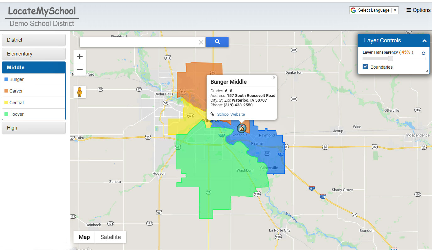
One of the most important and impactful trends in the last five years is visualizing data for greater ease of use and more effective communication. LocateMySchool is a web-based school locator and attendance boundary map. It serves as a convenient online service to communicate school boundaries, directions, and other information about your schools and district to your community. It allows parents to access current school attendance areas online, get walking, driving or bicycling directions to schools, along with other helpful information—from bus stop locations to a list of upcoming events and their locations. It provides school and district staff a tool at their fingertips to address inquiries, provide information to board members, or to help with school planning.
“Having all this data in one place has streamlined internal and external communication processes in our transportation department.”
Freddy Cornejo
Brawley Elementary School District
Director of Transportation (Retired)

Save Time:
By adding LocateMySchool to your district’s website, visitors can see school boundaries, get directions from an address to its assigned schools, see aerial maps of the district and surrounding area, obtain school and district contact information, and more. LocateMySchool will save your district time by making your school boundary information available online. Members of the public can find the information they need, any time of day, without having to call the school or district. District personnel in your planning and transportation departments, registration office, and school administration offices will be more efficient in answering the questions they receive.
Ensure accuracy:
We use GIS (Geographic Information System) technology to precisely plot your boundaries on an online map, preventing confusion that can occur when looking at hand-drawn boundary maps. We update your data and boundaries quarterly, and the map itself will update with new streets periodically based on Google Maps data.
Ease of use:
The initial setup is straightforward and painless; provide us with your district and school boundaries, and we do the rest. The application is simple for the public to use, even for those lacking computer skills. Website visitors enter their address in a search bar to see their students’ school assignments, get school information, get directions, and even get bus stop or crossing guard locations in the area. LocateMySchool is online, works on desktops, laptops, tablets, and mobile phones for convenient access any time.
How to Purchase LocateMySchool
See examples of LocateMySchool by selecting “Highlighted Projects.” Or visit our interactive self-guided demonstration site to see how it works by selecting “LocateMySchool Demonstration.”
LocateMySchool is extremely affordable. Implementation generally takes from four to six weeks.
| Annual LocateMySchool Subscription Prices | ||
|---|---|---|
| School District Size | Year 1 | Year 2+ |
| 1 to 20 school sites | $1,750 | $1,500 |
| More than 20 school sites | $1,750 + $100 per site over 20 | $1,500 + $50 per site over 20 |
Additional data layers, such as school board zones, crossing guard locations, bus stop locations, or after-school program locations, are available at an additional cost.
Get a Map Package of digital and printed maps of your district.
Contact us to receive a personalized quote or more details on product features.